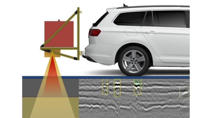
ZEB and Georadar data acquisition
As part of the ZEBRA research project, which was launched in November 2022, a new method is to be developed for the combined recording and AI-based evaluation of road conditions. The data basis for this will be the surface properties (evenness and substance characteristics) recorded during the condition monitoring and assessment (ZEB) as well as data from a georadar. The aim is for the data to be collected with a single drive and then evaluated and assessed by an automated process and the use of artificial intelligence.
For the analysis of the structure and condition of the road pavement, drill cores usually have to be taken. This represents a destructive intervention in the pavement and only allows a selective evaluation of the local situation. The use of a Ground Penetrating Radar (GPR) allows a non-destructive analysis of the pavement structure and the detection of anomalies. However, GPR is currently very rarely used because it only provides information on the layer structure - not on the condition of the pavement. In the case of condition detection and assessment (ZEB), on the other hand, only the externally recognizable condition of the pavement surface is detected and assessed. In both procedures, manual evaluations are usually necessary, e.g. for the detection of surface damage (cracks, breakouts, patches, etc.) from the high-resolution surface images or the determination of the layer boundaries in the pavement structure from the radargram.
The project objective of "ZEBRA" is the development of new methods for a combined or automated recording and evaluation of the surface properties and the layer structure of municipal roads. For this purpose, modern methods of digitization and artificial intelligence (AI) are to be used. The required data (surface and route images, longitudinal and transverse profiles of the road surface as well as longitudinal sections through the road structure) are to be collected with only one inspection. For this purpose, an appropriate measurement system will be set up and used in practice. In addition to the hardware, new methods for data management and data processing are to be developed. The solution will be validated using the example of the city of Kaiserslautern and will then be available for use in municipal condition monitoring.
The acronym "ZEBRA" stands for "ZEB and Georadar Data Acquisition and Combined Condition Assessment of Municipal Roads Using Automated AI Analysis Methods." The project builds on the findings of the predecessor project "RADSPOT" realized at the Chair of Mechatronics in Mechanical and Automotive Engineering (MEC) of the TU Kaiserslautern together with other cooperation partners.
In the ZEBRA project, the Technical University of Kaiserslautern coordinates the network and realizes the project together with the Gesellschaft für Geowissenschaftliche Dienste mbH and the HELLER Ingenieurgesellschaft mbH.
![[Translate to en:]](/fileadmin/Bilder/BMDV_Fz_2021_Web2x_de.gif)